This hike leads you to an enchanting waterfall on the Appalachian Trail
By Aislinn Sarnacki
Surrounded by slate walls that reach up to 90 feet tall, Little Wilson Falls is one of the most impressive waterfalls — or series of waterfalls — in Maine. And it’s fairly accessible, if you find yourself in that neck of the woods, which is exactly what happened to me recently.
On an overcast day in early July, I was on assignment in the small town of Monson, and I had some time to kill before heading home. In that area, there are many options for small outdoor adventures.
The famous Appalachian Trail – a 2,190-mile footpath – runs right through town. So you can always hop on that and walk for however long you please. In addition, Borestone and Barren mountains, both great hikes, are located nearby. But I was looking for something new, and I’d never hiked to Little Wilson Falls.
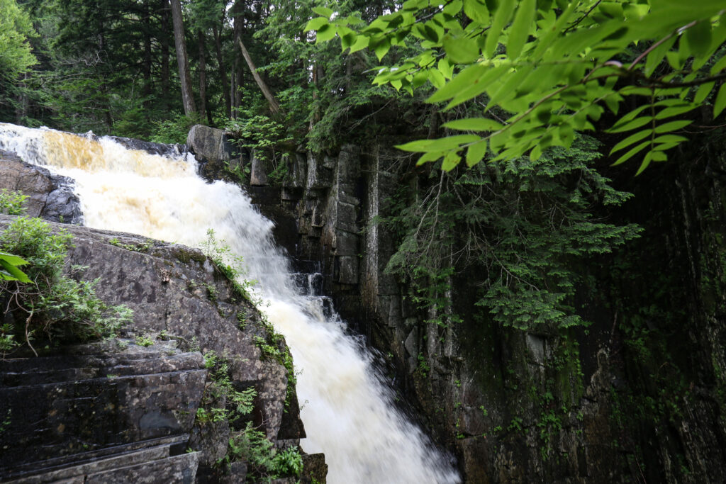
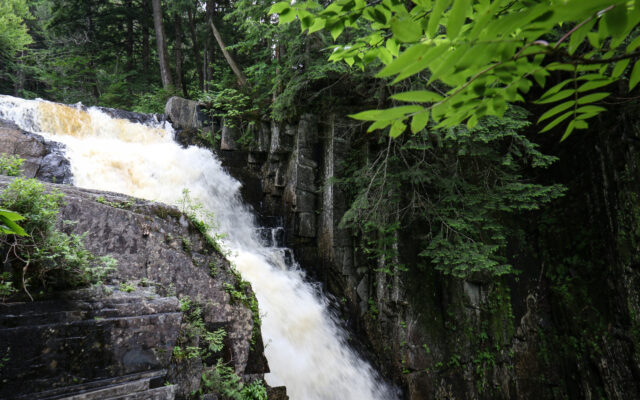
UPPER FALLS — The upper falls of Little Wilson Falls tumble over a series of steep slate steps on July 13, near the Appalachian Trail in Elliotsville Township.
The hike, out and back, is just under 2.5 miles. However, you might have to add 1.6 miles onto that, depending on where you park. I’ll explain.
From Monson General Store, where I enjoyed a hardy Trailblazer Sandwich, it was just a 20-minute drive to the trailhead off of Elliotsville Road.
There are two parking options: About 7.5 miles down Elliotsville Road, just before the bridge over Wilson Stream, is a parking lot on your left. You can park there and walk into the trailhead on the narrow, gravel Little Wilson Falls Road. Or, if you have a vehicle with high clearance, you can drive down Little Wilson Falls Road about 0.8 mile to the day use parking lot at the end. This is where you’ll find the trailhead, marked with a sign.
I braved the road with my Subaru, rolling through several sizable puddles along the way. As I crept down the road, I noticed a few primitive campsites. And at the parking area at the end of the road was a picnic site that included a wheelchair-accessible picnic table.
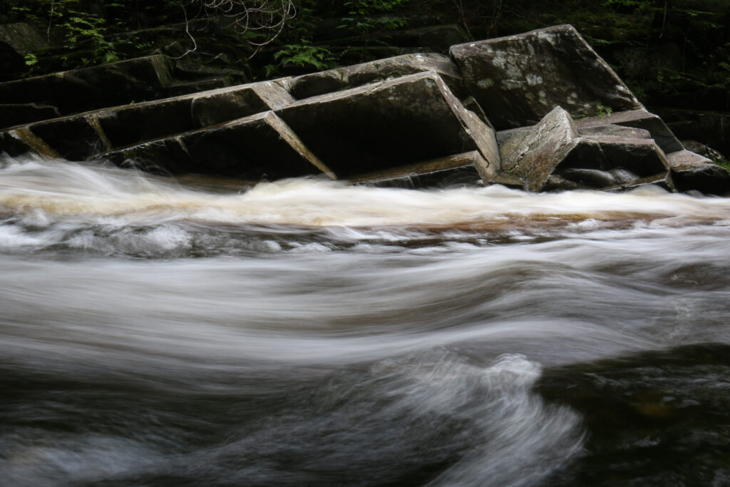
ANGULAR SLATE FORMATIONS — Water rushes past angular slate formations on Little Wilson Stream on July 13, in Elliotsville Township.
The property is owned by Elliotsville Plantation, but the trail is maintained by the Maine Appalachian Trail Club. That’s because, in addition to traveling to views of Little Wilson Falls, the blue-blazed trail connects to the AT, providing access to a remote section of the famous trail.
Little Wilson Falls is actually a series of falls divided into upper, middle and lower — with the upper falls being the tallest and most dramatic.
The height of waterfalls seems to differ greatly by source, and I don’t know how to measure them myself.
For the upper falls, I’ve seen everything from 40 to 75 feet tall. But in the 1981 “A Critical Area Survey of the Appalachian Trail in Maine,” the height of the upper falls was recorded as 42.6 feet, which seems too specific to be inaccurate.
The middle and lower falls aren’t mentioned as often in text. Newenglandwaterfalls.com, a great resource, has the middle falls at 25 feet tall, and the lower falls at 18.
The trailhead is located right by the lower falls, which can be viewed from a number of side trails that lead to the streambank. Just be sure to watch your step when walking over the slate bedrock along the edge of the stream. It’s especially slippery when wet.
The trail is moderately challenging due to plenty of exposed tree roots and rocks, plus the fact that it travels steadily uphill. The total elevation gain is 476 feet, according to “Hiking Waterfalls Maine,” a 2020 guidebook by Maine author Greg Westrich.
Following alongside the waterway, the weaves through a mossy forest filled with tall fir and cedar trees. On the day I hiked it, due to recent rain, colorful mushrooms dotted the forest floor. Orange, yellow, red, ghost white — they added a bit of whimsy to the landscape.
One cool component of the hike was all the slate. A metamorphic rock, slate easily breaks into smooth, flat sections that can appear manmade. Throughout the forest, thin sheets of the dark gray rock protruded from the mossy forest floor in a way that reminded me of old tombstones.
I’ll be honest, I missed the middle falls entirely. I noticed a few pretty cascades through the trees, but I didn’t pause to enjoy them. I was too focused on my destination: upper falls.
The upper falls is actually located on the AT. After about a mile, Little Wilson Falls Trail ends at the AT, where you turn left and follow white blazes to upper falls in about 0.2 mile. There you’ll find two side trails. One leads to a view about halfway up the waterfall, while the second leads to a view at the top of the falls.
Exercise care while approaching the viewpoints, which are both at the edge of tall cliffs. I did a bit of crawling and scooting on my butt to avoid any accidents.
The slate cliffs are a study of vertical lines and blocks. With vegetation growing out of the cracks, they reminded me of the ruins of a castle.
Using waterfall terms, the upper falls is called a “horsetail,” meaning it’s long, thin and fans out at the end. Horsetail waterfalls drop off a steep cliff face but maintain contact with the rock beneath. In this case, the waterfall runs a series of steep rock steps.
When I visited, the water level was high and the falls were roaring. I could barely make out the steps underneath the frothing water. But I’ve seen photos of the waterfall during times when less water was flowing. It looks like a giant slate staircase.
I highly suggest this hike. Take a trip to Monson, grab an awesome sandwich from Monson General Store and make a day of it.