This scenic snowshoe on the Appalachian Trail leads to a frozen waterfall
Difficulty: Moderate. The hike is 3 miles, out and back. However, you may need to park up to 0.8 mile away from the trailhead depending on snow conditions, your vehicle’s capabilities and whether or not the trailhead parking area is full. This would increase the distance of your hike to 4.6 miles. The trail is hilly and features plenty of roots and rocks, making footing tricky in some areas. Your destination, the upper falls, is more than 200 feet higher in elevation than the trailhead (which makes sense, since water flows downhill).
Information: Little Wilson Falls is a series of three waterfalls on Little Wilson Stream as it flows through a dramatic slate gorge in Elliottsville Township. A 3-mile out-and-back hike leads to the largest of these waterfalls, which is known as the “upper falls” and is located on the Appalachian Trail.
The hike begins at the end of a bumpy, gravel access road off Elliottsville Road. At the trailhead is limited space to park, as well as a day use area with an open space for picnicking and a view of the stream’s lower falls.

Bangor Daily News photo/Aislinn Sarnacki
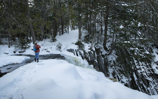
LITTLE WILSON FALLS — Derek Runnells stands at the top of the upper falls of Little Wilson Falls, which drop about 40 feet into a slate gorge in Elliottsville Township.
The lower falls are 18 feet tall; the middle falls are 25 feet tall; and the upper falls are the tallest at about 40 feet tall, according to the third edition of “New England Waterfalls: A Guide to More than 500 Cascades and Waterfalls” by Greg Parsons and Kate B. Watson.
The majority of the hike is on a 1.3-mile side trail to the Appalachian Trail. Marked with bright blue blazes, this trail start beside Little Wilson Stream and heads uphill into the forest. The trail follows the stream and over hilly terrain.
The trail veers away from the stream before the middle falls. Instead of visiting the waterfall, it travels uphill, away from the water, and along the top of a steep slope. This section of the trail is particularly beautiful, with many large hemlock trees towering overhead. You’ll also come across a few impressively large cedar trees.
Where the trail ends at the Appalachian Trail — 1.3 mile into the hike — there’s a sign that directs you left to upper falls. (There’s also a sign that directs you to the Little Wilson Falls trailhead, if you get confused on the way back.) From there, it’s just 0.2 mile to upper falls, where there are two overlooks: one part way up the falls and one at the top.
Marked with white blazes, the Appalachian Trail is a continuous footpath that runs from

Photo courtesy of Derek Runnells
HIKING COMPANION — Bangor Daily News reporter Aislinn Sarnacki and her dog, Oreo, hike along a trail leading to Little Wilson Falls on Dec. 8 in Elliottsville Township.
Springer Mountain in Georgia to Katahdin, Maine’s tallest mountain. A popular route for backpackers and day hikers alike, the trail is about 2,200 miles long and crosses 14 states.
The Maine Appalachian Trail Club maintains the majority of the Appalachian Trail in Maine — 267 miles, to be specific. The club also maintains many side trails that offer access to the trail for day hikers, including the side trail that leads into Little Wilson Falls.
The nonprofit organization was founded in 1935 and is entirely run by volunteers.
The hike is on property that’s owned the Elliotsville Plantation Inc. Dogs are permitted but must be cleaned up after and kept under control at all times. While the areas by Wilson Stream along the access road used to be campsites, they’re now open for day use only.
For more information about hikes on the AT in Maine, visit matc.org. The club regularly updates and publishes a detailed guidebook and series of maps for the AT in Maine that’s available through the MATC online store.

Bangor Daily News photo/Aislinn Sarnacki
STEEP FALLS — The upper falls of Little Wilson Falls in Elliottsville Township are about 40 feet tall. The water plunges down into a dramatic slate gorge with almost vertical walls.
Personal note: “Warning. Bear and cubs in 0.25 mile,” I read to my husband, Derek, as he buckled into his snowshoes.
The notice was hand-written on a piece of lined notebook paper, which had been slipped behind the glass of a kiosk at the end of the gravel road.
“Oh. Nevermind. It was written in June,” I said, noticing the scribbled date. “The bears should be hibernating now.”
I gave Derek what I hoped was a confident smile. It was a chilly Sunday in early December, and our plan was to snowshoe to Little Wilson Falls. We’d arrived to find the access road unplowed, so we’d parked at the end and quickly prepared to set out. Hiking into the trail on the road would tack 1.6 miles onto our trek, and the sun was already headed toward the horizon.
“We’ll have to move fast,” I said, speaking more to myself than to Derek. After all, I’m the one who stops to take photos of the smallest things — the tracks of a snowshoe hare, a bead of ice on the tip of a branch, snow fleas.
That day, we covered 4.6 miles in about 2.5 hours, returning to our vehicle before sundown. Along the way, we peeled off our outer jackets and mittens to cool down, even though the temperature only peaked in the mid-20s. Snowshoeing is tough work. By the end of it, we were toast.
For me, highlights of the hike were the large hemlock trees we passed in the forest and the massive slate walls of the gorge. The dark rock was striated, with lines running vertically throughout. Snow dusted this texture, and the effect was striking.
That day, the upper waterfall was a combination of rushing water and interesting ice formations. It was a beautiful sight, but I’d like to return in the summer to see what it looks like without snow and ice covering the forest floor and rock ledges. That’s one cool thing about hiking in Maine year round. Trails change with the seasons.
How to get there: Starting in downtown Monson, drive north on Main Street (Route 15-Route 6) and turn right onto Elliottsville Road (about 0.6 mile north of the fire department, which is located at 200 Main Street). Drive 7.6 miles and the gravel access road to the trailhead is to your left, just before the bridge over Wilson Stream. (The road after the stream leads to Borestone Mountain.) High clearance vehicles are recommended to drive up the access road, which is 0.8 miles long. If you don’t want to drive on the rough road, there’s a small area where you can park at the beginning of the road. There are also a couple turnouts along the road where one or two vehicles could park. And at the end of the road, parking is limited by the trailhead. During the winter, it’s likely that this road is not plowed. The only option is to park to the side of the Elliottsville Road, out of the way of traffic, and hike into the trailhead on the access road, adding a total of 1.6 mile (0.8 mile, out and back) to your hike. Do not park on a bend in the road, and do not block any driveways.
For more of Aislinn Sarnacki’s adventures, visit bangordailynews.com/act-out. Follow Aislinn Sarnacki on Twitter: @1minhikegirl, and Instagram: @actoutdoors. Her guidebooks “Family Friendly Hikes in Maine,” “Maine Hikes Off the Beaten Path” and “Dog-Friendly Hikes in Maine” are available at local bookstores and wherever books are sold.