Turtle Ridge offers amazing views from dramatic cliffs in Nahmakanta Public Lands
Difficulty: Moderate to strenuous, depending on how much of the trail network you hike. Altogether, the trails on and around Turtle Ridge total 9.3 miles; however, it’s easy to map out shorter hikes — including loop hikes — in that network. For example, from the west trailhead, it’s just a 3-mile out-and-back hike to the viewpoints on Turtle Ridge. The trails feature plenty of roots and rocks. Near the ponds, the trails are fairly flat, while on the ridge, the slope is gradual with only a few steep sections.
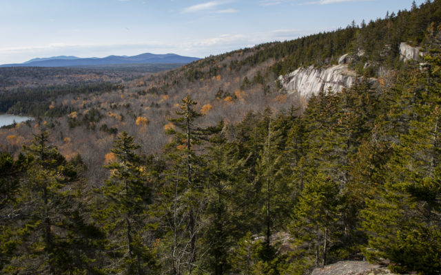
Information: One of the most distinctive landmarks in Nahmakanta Public Lands, Turtle Ridge rises above Sing Sing Pond, its dramatic cliffs serving as a beautiful backdrop to the water. The ridge tops off around 1,600 feet above sea level and features several overlooks.
A well-maintained trail network explores the Turtle Ridge and visits the nearby Sing Sing, Henderson, Long, Rabbit and Hedgehog ponds. Altogether, these intersecting trails total 8.4 miles, not counting the 0.9-mile trail that branches off to visit staircase falls on a nearby stream.

Bangor Daily News photo/Aislinn Sarnacki
TURTLE RIDGE — An overlook on Turtle Ridge gives an interesting perspective of nearby cliffs on the same ridge on Oct. 24 in Nahmakanta Public Lands.
Marked with blue blazes, the trails form a figure eight, with signs at each intersection directing you to key landmarks. Throughout the network, the scenery changes several times. Some highlights include mossy stands of tall evergreens, vast beds of pale lichen atop the ridge and areas filled with giant boulders left behind by a glacier thousands of years ago.
The trails also pass along interesting rock formations, including long rock walls that are so uniform they look almost man-made. On the east side of Turtle Ridge, the trail travels along the base of some cliffs, where a small cave can be found. And just beyond that, the trail travels along an esker (a long ridge of sediment) between two small ponds.
Atop Turtle Ridge, overlooks offer views of Sing Sing Pond and distant mountains to the south. In addition, a smaller ridge to the east features an open view of Katahdin and other mountains of Baxter State Park. This overlook is reached by hiking the section of the trail network that visits Henderson Pond.
Some man-made features of the hike include a scenic wooden bridge over a bubbling brook, a series of narrow bog bridges, a few stone staircases, large rock piles called cairns marking the trail in some places on the ridge and a rock border to the trail near the viewpoint of Katahdin.
The name Turtle Ridge begs for some explanation. To learn more, I searched the pages of Steve Pinkham’s book “Mountains of Maine: Intriguing Stories Behind Their Names.” In the book, Pinkham reports that the ridge may be named after its turtle-like shape or in honor of the turtles living in nearby ponds.
Pinkham also came across local lore that states that Sing Sing Pond was named after Sing Sing Correctional Facility, a famous maximum security prison in New York, and that the pond’s dark water may have reminded early lumbermen of the dark confines of the prison.
Nahmakanta Public Lands is a state-owned chunk of conservation land deep in the woods, about halfway between Moosehead Lake and Millinocket. The unit encompasses 43,000 acres and features small mountains, 24 “great ponds” (10 or more acres in size), 22 campsites and about 35 miles of hiking trails, in addition to 9 miles of the famous Appalachian Trail.
Aside from the fees paid at the Jo-Mary Checkpoint, access is free. Camping on the property is first come, first serve. Dogs are permitted if under control at all times. Hunting and trapping is permitted, in accordance with state laws. For more information about Nahmakanta Public Lands, call 207-941-4412 or visit maine.gov/nahmakanta.
Personal note: Nahmakanta is an outdoor destination that has long been on my radar, but for whatever reason, it took me years to check it off my list. You know those places that just seem to elude you? Well, I finally made the trip, thanks to the planning of three friends: Kris Reid, Betty Jamison and Wanda Greatorex.
I woke up before dawn, met my three companions and headed into the woods, leaving civilization and cellphone reception behind. After getting settled at Kris’s nearby camp, we packed lunch and hiked Turtle Ridge, a place that holds many memories for Kris and her family.
We parked a car at both trailheads so we could hike from one end to the other, traveling over Turtle Ridge and then to the viewpoint of Katahdin near Henderson Pond. Throughout the 5.5-mile hike, we passed through some truly wondrous scenery. One of my favorite areas was the boulder-filled forest just east of Turtle Ridge. I also enjoyed the large white birch trees near the west trailhead, and the stand of tall spruce trees near Sing Sing Pond. It seemed that every few minutes, a new natural wonder would pop into view.
I could write pages about our hike, about the chickadees that serenaded me as I walked along the esker and many colorful mushrooms we spotted along the trail. But I’m short on space, so I’ll just say this: It was worth the long drive. Nahmakanta is a beautiful place, and while it’s now checked off my list, I plan to visit again soon.
How to get there: From the center of Milo (where routes 11, 6 and 16 intersect) drive north on Route 11 for 23.4 miles, then turn left at the Jo-Mary Lake Campground sign onto the gravel Jo-Mary Road. This is a well-maintained logging road. Drive slowly and yield to logging trucks.
Reset your odometer. In about 0.2 mile, you’ll come to Jo-Mary Road Checkpoint. Pull over to the right and enter the gatehouse to register and pay a road use fee of $10 for Maine residents (per day), and $15 for non-residents, cash or check only. The checkpoint is open from 6 a.m to 9 p.m. daily, May through the middle of October, with the hours extending to 10 p.m. on Fridays and Saturdays. Off season, the public does not need to register or pay a fee to use the road, however, many of the roads are not plowed, and some are used by snowmobiles.
After registering, continue on Jo-Mary Road for about 14.5 miles to Henderson Brook Checkpoint, which is an unmanned, electronic checkpoint manned by Jo-Mary staff. Along the way, several roads branch off Jo-Mary Road. I suggest carrying Delorme’s The Maine Atlas and Gazetteer to trace your route as you drive. Also, at some intersections, you can follow signs that read NLC (Nahmakanta Lake Camps) and DLWC (Debsconeag Lake Wilderness Camps). The biggest intersection is at about 6 miles, where you’ll veer right.
Just beyond the Henderson Brook Checkpoint, you’ll enter Nahmakanta Public Lands. About 1.7 miles past the checkpoint, the parking area for the east trailhead for Turtle Ridge is on your left. After parking, walk back along the road a short distance to find the trailhead, which is on the same side of the road as the parking.
To reach the west trailhead to Turtle Ridge, continue on Jo-Mary Road to about 5.7 miles past the Henderson Brook Checkpoint, then turn left onto Nahmakanta Road. Drive about 1.3 mile, then turn left onto Long Pond Road. Drive 1 mile and the trailhead parking area is on your right. Park and continue down the road on foot. Cross a bridge and the trailhead will be on your left.
For more of Sarnacki’s adventures, visit bangordailynews.com/act-out. Follow her on Twitter: @1minhikegirl, and Instagram: @actoutdoors. Her guidebooks “Family Friendly Hikes in Maine,” “Maine Hikes Off the Beaten Path” and “Dog-Friendly Hikes in Maine” are available at local bookstores and wherever books are sold.