North Traveler Mountain is one of the most challenging hikes in Baxter State Park
Difficulty: Strenuous. The hike is 5.6 miles, out and back, and features long stretches of steady climbing, a few steep scrambles and very uneven, rocky footing. The hike does not include much hand-over-foot climbing.
How to get there: Take Interstate 95 Exit 264, then head north on Route 11 toward the town of Patten. Drive 9.3 miles, then take a left onto Route 159. Drive 9.9 miles and you’ll arrive at Shin Pond Village. Drive another 14.3 miles, staying on Route 159, and you’ll reach Matagamon Wilderness Campground, then cross a bridge over the East Branch of the Penobscot River. Continue another 1.8 miles to Matagamon Gate, the north entrance to Baxter State Park. Register at the gatehouse, which is open 6 a.m. to 10 p.m. Continue past the gate and drive about 7 miles on the Park Tote Road, then turn left onto South Branch Pond Road. Drive about 2 miles and park in the day use parking area of South Branch Pond Campground.

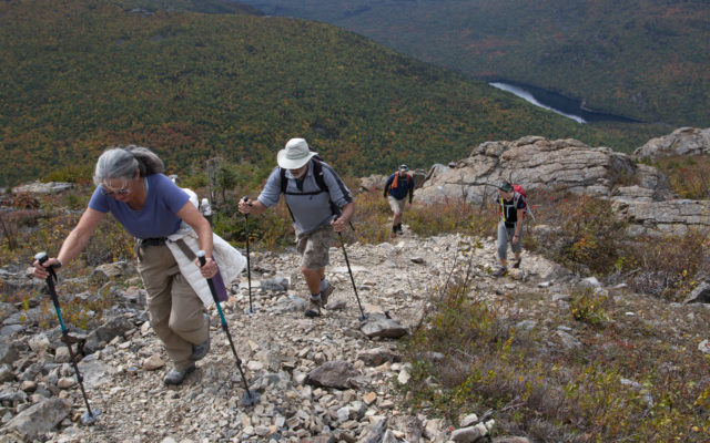
Bangor Daily News photo/Aislinn Sarnacki
NORTH TRAVELER MOUNTAIN — From left, Gail and Jim White of Orono hike up North Traveler Mountain in Baxter State Park on Sept. 28, with their son, Jason White, and friend Shelby Boynton-Yazel.
On foot, follow the gravel road through the campground. You’ll pass the ranger station and the road will take you along the edge of Lower South Branch Pond. The trailhead is at the east end of the campground. Start the hike on Pogy Notch Trail.
Information: North Traveler Mountain features one of the most challenging hikes in the north end of Baxter State Park. Topping off at 3,144 feet above sea level, the mountain is a part of a long, curving range that rises above Upper and Lower South Branch ponds.
One of the great things about North Traveler Mountain is that hikers are rewarded with amazing views early on in the hike. The first viewpoint is just 0.6 mile from the trailhead, and above that, the trail is open to the sky much of the way as it travels along a steep, rocky ridge.
The hike begins on Pogy Notch Trail with a series of narrow bog bridges under a leafy canopy not far from the shore of Lower South Branch Pond. At 0.1 mile, North Traveler Trail spurs off to the left, leaving the Pogy Notch and the ponds behind.
North Traveler Trail starts out with a gradual incline as it approaches the rocky ridge that runs up the east side of the mountain. Before long, the trail becomes notably steep with stone staircases that are so varied they almost look natural.
About 0.5 mile into the trail, you’ll come to a rocky side trail that leads to a ledge overlooking the South Branch ponds. From there, on a clear day, you can see Katahdin to the south.

Bangor Daily News photo/Aislinn Sarnacki
VIEW FROM THE TOP — Some of the mountains and hills in the north end of Baxter State Park are seen from the top of North Traveler Mountain in Baxter State Park.
From there, the trail travels along the edge of a steep, rocky slope. This may not be a fun section for people who are afraid of heights. However, this exposed section of the trail offers views that only seem to improve with each step.
As you hike, you may notice that the rocks on this mountain look different than the rough granite found on Katahdin and other mountains further south in the park. That’s because coarse-grained Katahdin Granite underlies the southern half of Baxter State Park, while finer-grained Traveler Rhyolite covers a large area in the northern half of the park, including Traveler Range, according to the Maine Geological Survey.
Both the granite and rhyolite have the same composition, just different sized grains. They were a part of a large volcanic system that was active millions of years ago. The Traveler Rhyolite is typically dark gray tinged with green or blue, however, its weathered surfaces (like those found atop North Traveler) may be white, light gray or stained brown or red by iron. You’ll also notice that the rock is broken cleanly in places, creating blocks and columns. This is the result of fractures that formed when layers of the volcanic rock cooled rapidly.
As you continue your climb, beware that North Traveler is known for having multiple “false summits.” You may see what looks like a peak ahead, but when you reach it, another higher point will appear. Adding to this illusion, many of these false summits are topped with giant rock piles called cairns.
Aside from these occasional cairns, the trail is marked with blue painted blazes, which mark trees and bedrock along the way.
As the trail nears the summit of North Traveler, it levels off a bit and travels through a few different habitats, including a stand of big beautiful white birch trees and tall ferns. The trail also travels through a couple alpine meadows, which are filled with a variety of low-lying plants and wispy grasses. And just before the summit, the trail passes through a mossy forest of stunted evergreen trees.
Wild blueberries grow trailside throughout much of the hike and are especially abundant near the top of the mountain. These berries likely attract blackbears, the evidence of which (skat) can often be found on the trail.
The summit of the mountain is marked with a sign that’s held up by a small rock pile. Free of trees, it offers a 360-degree view of the region. In fact, the summit is the first place in the hike where you’ll get a view to the north and west. To the north, you’ll see the long, shining expanse of Grand Lake Matagamon, and nearby are several small mountains, including Trout Brook, Horse, Barrel Ridge and Bald.
If hiking to the summit and back, retracing your steps, the hike is about 5.6 miles. However, some people continue on the trail past the summit to complete the Traveler Loop, which is over 10 miles and visits three additional peaks, including the taller Traveler Mountain. This loop can be hiked in either direction, though most suggest hiking it counter-clockwise, hitting North Traveler last.
Pieced together by former Maine Gov. Percival P. Baxter between 1931 and 1962, Baxter State Park covers 209,644 acres north of Millinocket. Baxter is home to more than 200 miles of hiking trails that visit pristine ponds, waterfalls and a number of sizable mountains.
Dogs are not permitted. Camping is by reservation. Park roads are closed to vehicle traffic in the winter. For more information, call 207-723-5140 or visit baxterstatepark.org.
Personal note: Raindrops dimpled the surface of Lower South Branch Pond on the morning of Sept. 28, but the clouds were high, revealing the impressive mountains that rose up from the forest. In the north end of Baxter State Park, the fall foliage was nearing its peak. Aspen and birch trees displayed bright yellow leaves, while maples were turning red and red-orange.
It was the Saturday of my family’s semi-annual camping trip in Baxter, and I’d decided to hike North Traveler Mountain, a peak I last climbed when I was just 16 years old. Joining me on the hike was my uncle and a few family friends who were looking for a bit of a challenge. Others in our camping group went canoeing and fishing that day, and one simply read a good book and lounged around camp. Everyone has a different idea of what constitutes “fun” in Baxter.
We got lucky that day. As we hiked, the rain stopped and the clouds parted to reveal a bit of blue sky and sun. Fall colors dotted the landscape, and the wild blueberries growing alongside the trail made for a perfect on-the-go snack. (I was surprised the berries were still good so late in the year.)
Near the top of the mountain, we came across a spruce grouse, a beautiful bird that is fairly uncommon and therefore illegal to hunt in Maine. A species known for its tame demeanor, the grouse simply sat on a moss-covered tree branch and watched us as we hiked by.
Several piles of bear skat, filled with blueberries, had been left on the trail, but we never spotted the culprit.
By the time we got to the summit, darker clouds were rolling in. We remained just long enough to eat a picnic lunch, then headed back the way we came, arriving at the campground as it was just beginning to rain.
For more of Aislinn Sarnacki’s adventures, visit bangordailynews.com/act-out. Follow Aislinn Sarnacki on Twitter: @1minhikegirl, and Instagram: @actoutdoors. Her guidebooks “Family Friendly Hikes in Maine,” “Maine Hikes Off the Beaten Path” and “Dog-Friendly Hikes in Maine” are available at local bookstores and wherever books are sold.