Shaw Mountain near Moosehead offers a quiet hike, nice views and abundant wildlife
Difficulty: Moderate. The hike, out and back, is 3.6 miles if you only visit the Middle Summit and viewpoint, and it’s another 0.4-mile if you add the short side trail to the forested North Summit of the mountain. The hike is mostly gradual but includes a few short steep sections and rock staircases.
How to get there: From the traffic light at the center of downtown Greenville, drive north on Lily Bay Road (around the east side of Moosehead Lake) for 19 miles to Kokadjo. Pass Kokadjo Trading Post and Convenience Store, then bear left where the pavement ends. Drive 1.6 miles, then bear right at the sign for Medawisla Lodge. Continue on this road for approximately 6 miles to reach the lodge. The turn to Medawisla Lodge will be on your left and marked with a sign. Instead of visiting the lodge, continue straight on Smithtown Road for about 1 mile, then turn right onto Shaw Mountain Road. Drive about 0.8 miles to the small parking area for Shaw Mountain, a gravel turnout on your right. The trailhead is across the road from the parking area, marked with a small wooden sign.

Bangor Daily News photo/Aislinn Sarnacki
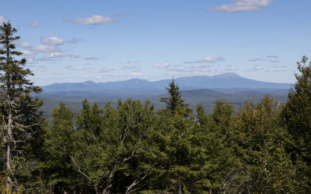
SHAW MOUNTAIN — The mountains of Baxter State Park can be seen from a viewpoint near the top of Shaw Mountain on Sept. 1, east of Moosehead Lake.
Note that the roads beyond Kokadjo are not paved, and are subject to washouts and potholes. Roads may not be passable by cars with low clearance. Limit your speed to 25 mph, and yield to logging trucks.
Information: Located among the Roach ponds east of Moosehead Lake, Shaw Mountain tops off at 2,631 feet above sea level. Though it’s fairly small compared to other mountains in the region, it offers a moderately challenging hike to views of Second Roach Pond and, on a clear day, the mountains of Baxter State Park.
The mountain was named after a lumber baron, according to Steve Pinkham’s book “Mountains of Maine: Intriguing Stories Behind Their Names,” and it has three summits — North, Middle and South. It’s located on land owned by the Appalachian Mountain Club, a nonprofit organization that has conserved about 70,000 acres of forest land and created over 120 miles of recreational trails in and around Maine’s 100-Mile Wilderness Region.
Starting at the base of the mountain, Shaw Mountain Trail follows a bubbling brook through a mostly deciduous forest to the mountain’s northeast slope, then gradually begins to climb. The trail is marked with red diamond signs that are nailed to trees.
At 0.6 mile, Shaw Mountain Trail meets the Skyline Trail, which is noticeably wider and surfaced with gravel for mountain biking. Turn left and follow the Skyline Trail for a few hundred feet until you see the Shaw Mountain Trail veer off on your right, marked with a red sign.
Continue to follow the Shaw Mountain Trail through a forest that is still largely deciduous. This section of trail is a little steeper than the last. In 0.3 mile, the trail meets the Skyline Trail again. This time it crosses the trail immediately rather than following it for a stretch. From there it’s just 0.2 mile until the trail intersection between the mountain’s North and Middle summits. Along the way, you’ll climb a scenic rock staircase.
At the trail intersection near the top of the mountain, you can turn right to hike 0.2 mile to the North Summit or left to hike 0.7 mile to the Middle Summit.
The North Summit rises 2,485 feet above sea level and is entirely wooded, therefore, it doesn’t offer any views. It’s the second tallest of the mountain’s three summits.
The Middle Summit rises 2,631 feet above sea level, making it the tallest of the three summits. Trees have been cut down near it to provide hikers with open views to the northeast of Second Roach Pond and Farrar Mountain. Also, on the way to the Middle Summit is a short side trail that leads to a vista where you can see the mountains of Baxter State Park on a clear day.
[image id=”2871779″ size=”full” pos=”center” /]
As of September 2019, trail work was underway to extend the trail from the Middle Summit to the nearby Hedgehog Mountain.
The trails on Shaw Mountain are marked on AMC’s Medawisla Summer Trails map, which is available at outdoors.org and at Medawisla Lodge. Dogs are permitted but must be under control and picked up after. For more information, call AMC’s Greenville office at 207-695-3085.
Personal note: After a peaceful night spent tenting on the banks of Trout Pond, my husband Derek and I decided to hike the nearby Shaw Mountain on Sept. 1. We chose the trail because of its proximity, not because it was on the top of my hikes-to-do list. But I’m glad we gave it a shot. It turned out to be a nice, quiet family-friendly trek.
Early in the hike I noticed a few orange poisonous mushrooms, their caps covered with raised white dots. I also noticed a variety of berries, including clusters of bright red hobblebush berries lining much of the trail. With large leaves that are somewhat heart-shaped, hobblebush is often found in the understory of Maine forests and along woodland edges, according to an article by Maine’s Wild Seed Project.
Farther up the mountain, we ran into several piles of moose poop, which are easy to identify because they’re so incredibly large. The skat is ball-shaped, like a deer’s, but much bigger. I paused to photograph it several times, which Derek found quite amusing.
Near the North Summit of the mountain we came to sign that cautioned us about a nearby spruce grouse nest.
“Maybe we’ll get to see one!” I whispered in an excited tone to Derek.
With our dog, Oreo, on leash, we walked the trail slowly, our eyes searching the underbrush, but we didn’t spot any of the rare birds. About the size of a chicken, spruce grouse are a less common relative of the ruffed grouse. And while the ruffed grouse is a popular game bird, state law dictates that spruce grouse cannot be hunted. The only time I’ve seen a spruce grouse is while hiking in the mountains of Baxter State Park. The ruffed grouse, on the other hand, scares the crap out of me on a regular basis by bursting forth from the underbrush when I’m hiking by. The thunder of their wings is startlingly loud.
At the Middle Summit we sat down on the soft forest floor to eat peanut butter and jelly sandwiches and enjoy the view, then we continued on to see the trail that’s under construction to Hedgehog Mountain. After a few hundred feet we decided to turn around and call it a day. We could hear a chainsaw buzzing up ahead and didn’t want to disturb the work crew.
For more of Aislinn Sarnacki’s adventures, visit her blog at actoutwithaislinn.bangordailynews.com. Follow Aislinn Sarnacki on Twitter: @1minhikegirl, and Instagram: @actoutdoors. Her guidebooks “Family Friendly Hikes in Maine,” “Maine Hikes Off the Beaten Path” and “Dog-Friendly Hikes in Maine” are available at local bookstores and wherever books are sold.